By Katarzyna Skiba
After every election in Poland, the country’s east-west political divide – which fits neatly over maps showing how the country was partitioned in the 19th century – prompts questions about the ongoing legacies of empire. But the issue is complex.
After last month’s Polish parliamentary elections, maps appeared on TV screens, in newspapers and across social media showing a clear and continuing divide between eastern Poland, which voted for the conservative ruling Law and Justice (PiS) party, and the western half of the country, which favoured the more liberal opposition.
It's 2023, 109 years after WW1 started, yet the pre-WW1 imperial borders are still visible on the election map of Poland – and on many others, for that matter.
A thread 🧵🧵🧵–> pic.twitter.com/ihNOHRniaP
— Szymon Pifczyk (@sheemawn) October 17, 2023
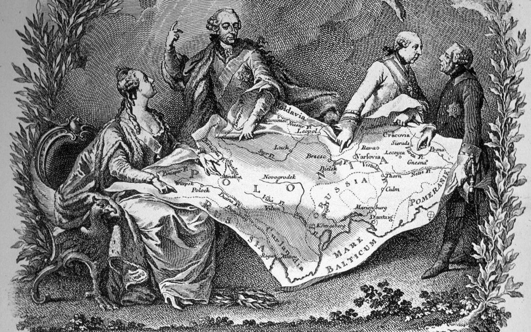
The reasons for this longstanding political divide are many. But in the media – and especially on social media – commentators frequently focus on one in particular, noting that modern-day voting preferences appear to fit neatly over the borders of Poland’s historical partitions, which began in the late 18th century and lasted until 1918.
During this time, Poland was wiped off the map, with its western and northern territories becoming part of the Kingdom of Prussia (later Germany), its eastern lands being annexed by the Russian Empire, and its southeast becoming part of the Habsburg Empire (later Austria-Hungary).
This meant that, throughout their 123 years of partitions, the territories of what is now Poland had very different experiences politically, economically, culturally and in many other ways.
In the latest episode of our Brief History of Poland podcast series, we look at the eighteenth-century end of independence.@StanleySBill talks about political disorder, Enlightenment and reform, Hasidic Judaism, the new constitution, and the partitions. https://t.co/cd9EJbj6Fn
— Notes from Poland 🇵🇱 (@notesfrompoland) May 1, 2021
Many have attributed not only Poland’s current political divides to these legacies of empire, but also broader differences in economic development, infrastructure, religiosity and a range of other indicators.
“The effects of the partitions are still felt today and concern almost every sphere of life,” says Tomasz Nakoneczny, a historian focusing on postcolonial studies in Central and Eastern Europe at Adam Mickiewicz University in Poznań.
But it is the political implications of the partitions that attract the most attention, including from international observers.
“Nowhere can the imperial boundaries be seen more starkly…than on Poland’s modern electoral map,” wrote The Economist in 2018. “Rather than following a gradual gradient from east to west, modern Poles’ political loyalties remain firm right up to the edge of the pre-1918 lines.”
Poles and Romanians still vote along 19th century imperial borders. Here's my data story for @ECONdailycharts on why the stubborn past is not dead, it is not even past. @TheEconomist https://t.co/2FiBTLYdPt pic.twitter.com/HsZyTrmLIk
— Maria Wilczek (@mariawilczek) November 21, 2018
However, many experts contend that the nature and extent of these differences, as well as the reasons behind them, are far more nuanced than such models may show.
“The problem is not so much that geographical divides don’t exist,” says Ben Stanley, an associate professor at the Centre for the Study of Democracy at SWPS University of Social Sciences and Humanities in Warsaw. “It’s the fact that the extent of those divides is always exaggerated by the way in which this information is presented”.
He notes the fact that such maps often use just two colours to show the most popular electoral choice in a region, rather than a gradient of colours that would show the more nuanced differences in party support.
They also typically show voting results by province – large administrative entities of which there are 16 in Poland – rather than by smaller administrative units that would again show a more nuanced picture.
A plea. In the next few days you will see maps like this one doing the rounds, with comments about Poland being divided in two and, if the person posting it is a bit more historically literate, about the decisive influence of the legacies of partition. Ignore such posts. pic.twitter.com/XahneXmHR1
— Ben Stanley (@BDStanley) October 16, 2023
According to Aleks Szczerbiak, a professor of politics at the University of Sussex, the real division in Poland is between big cities on the one hand, which tend to vote for the “liberal-left opposition”, and rural areas on the other, which tend to be pro-PiS. Smaller towns are somewhere in between.
“The west of Poland happens to have more of these cities”, says Szczerbiak, while noting that eastern cities, such as Rzeszów, Lublin, and Białystok, have significant populations that vote for opposition parties.
Another issue typically attributed to the legacy of the partitions is the economic divide between the richer west – often called “Poland A” – and the less-well-off east, “Poland B”. However, experts argue that, whatever validity those stereotypes may have held in the past, they are no longer quite true.
3. Back to Russia. Infrastructure is built for a looooong time. Over 100 years after Russia’s reign ended in this part of Poland, it still lacks access to bathrooms compared to the other parts. pic.twitter.com/pxBTVCd4ne
— Szymon Pifczyk (@sheemawn) October 17, 2023
The only economic measure that shows a significant jump at the partition border is access to railways,” says Irena Grosfeld from the Paris School of Economics.
“All other differences that we tested, including income, education, formal institutions, corruption and trust in government, withered away after the reunification of Poland [in 1918] and especially due to drastic institutional transformation during the communist time.”.
Further changes also took place after the fall of communism and Poland’s entry into the European Union.
“If you look at the data, the less developed part of Poland developed faster, rather than the more developed one, which means that the further we move to the west, the slower this development probably was,” says Piotr Koryś, author of Poland From Partitions to EU Accession: A Modern Economic History.
There has been “convergence” within the country and “today the differences between the regions of Poland are definitely the lowest in its history”, he adds.
Poland has overtaken Spain and is almost equal with Ireland in an index used by the EU to assess the material wealth of households in member states https://t.co/QkQ15B5O64
— Notes from Poland 🇵🇱 (@notesfrompoland) July 11, 2023
For Szczerbiak, it is more socio-cultural factors, such as religion, than the lingering legacy of the partitions that have an impact on the consistent divisions in voting patterns.
He notes that, in the so-called “recovered territories” – the western parts of Poland that before the Second World War were within Germany –the fact that many Poles do not have long-standing roots, having migrated from other areas, results in “not as much social capital”, which in turn leads to lower incentives to participate as actively in church life.
But even such differences have roots in the legacies of empire. In the former Austro-Hungarian territories, “there was a reasonable level of autonomy granted to Poles by the occupying powers”, says Stanley. “So Poles were able to preserve some sense of continuity of language, of culture, of national identification, even if they weren’t a nation with their own state.”
The Polish province of Warmia and Masuria, once part of East Prussia and a melting pot of nationalities, is a place where entire populations have been forced to flee, both to and from it.
Today that complex history is commemorated in a variety of ways https://t.co/fRB2U7eDX4
— Notes from Poland 🇵🇱 (@notesfrompoland) March 20, 2020
Still, even a factor this potent may be subject to change. “This correlation may become less significant in the future because of the powerful secularisation trend in Polish society”, argues Grosfeld.
Following the election results, state broadcaster TVP, which has been closely aligned with the ruling party, reported that “historical Poland” voted for PiS while the formerly German recovered territories voted for the opposition. That fitted PiS’s campaign narrative of seeking to portray its opponents as working in Germany’s interests.
However, again, such simplistic narratives hide a more complex picture.
“The countryside of the ‘recovered territories’ are the only places in rural areas where PiS gained voters” in these past elections, says Jarosław Flis, a sociologist at the Jagiellonian University and political commentator.
Generally, Poland’s electoral trends have relied upon parties gaining support where they performed worse in the past. This year, this was a key strategy employed by Civic Coalition (KO), the main opposition group, and their leader Donald Tusk.
“Because [they] did not focus on large cities, because Tusk travelled all over Poland, to smaller towns,” says Flis, the opposition “managed to reduce the differences between the support of large cities and rural areas”, something which he referred to as “a key phenomenon” politically.
PiS's vote share fell by over 8 percentage points between the 2019 and 2023 elections, and almost three quarters of that loss came in small towns and villages.@StanleySBill looks at how and why the ruling party lost power in its rural heartlands https://t.co/FRZCFgWiqw
— Notes from Poland 🇵🇱 (@notesfrompoland) October 30, 2023
There is no doubt that Poland’s turbulent history of partitions, occupations, population movements and border changes continues to have an impact on many aspects of modern life.
However, such a complex past cannot be boiled down to the simplistic interpretations suggested by maps overlaying 19th century borders onto modern voting patterns. Moreover, the legacies of that past are being felt ever less amid a period of unprecedented stability and development for Poland.

Notes from Poland is run by a small editorial team and published by an independent, non-profit foundation that is funded through donations from our readers. We cannot do what we do without your support.