Keep our news free from ads and paywalls by making a donation to support our work!

Notes from Poland is run by a small editorial team and is published by an independent, non-profit foundation that is funded through donations from our readers. We cannot do what we do without your support.
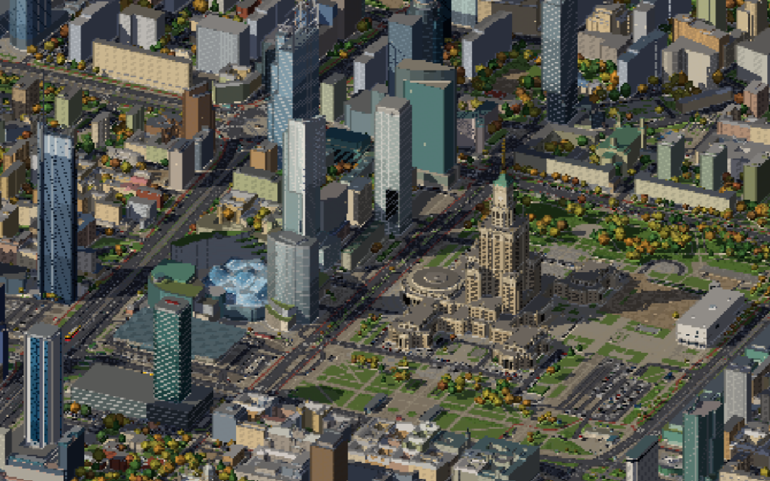
A Turkish software engineer has, with the help of AI and vast quantities of Polish public data, created a precise digital replica of Warsaw, the city where he lives.
The map, which can be explored for free online, features almost 200,000 buildings, moving trams that match their real-life schedules, changing light and weather conditions, and over 45,000 accurately placed streetlamps that turn on at night. It is even possible to fly a virtual plane through the city.
The person behind the project, Bedirhan Yildirim, was inspired by recent efforts to produce similar maps of New York and London.
While he initially considered producing one of Istanbul, his hometown, he decided instead to pick the city he lives in, Warsaw. “It is smaller, mostly flat, and I walk its streets every day,” he explained of his choice.
Yildirim then used AI coding agents to create the map through a process of trial and error, constantly tweaking and improving the model.
The initial version took only two days to produce and was launched on 22 October, but it has been regularly improved since then based on feedback from users.
The work was made possible by what Yildirim says is the “incredible amount of data” Poland’s national mapping office, GUGiK, provides for free, including 3D building models, terrain scans, and even details of almost 2 million trees.
Further information, including on parks, streetlamps, and traffic lights, was taken from OpenStreetMap, a freely licensed database. Meanwhile, timetables from Warsaw’s public transport authority, ZTM, and Poland’s national rail operator, PKP, allowed the map to feature accurately timed trams and trains.
Current weather conditions are input from Open-Meteo, an open-source meteorological service. But users can also choose to manually adjust the time of day or year, with light and weather changing accordingly.
An observation deck at the top of the EU's tallest building, Varso Tower in Warsaw, has opened to the public.
Located 230m up on the tower's 53rd floor, the attraction offers a 360° panorama of Poland's capital.https://t.co/VeEapOmh4s
— Notes from Poland 🇵🇱 (@notesfrompoland) September 9, 2025
The result is an incredible level of explorable detail, from major landmarks, such as the communist-era Palace of Culture and Science and Varso Tower, the EU’s tallest building, down to the seating steps and bars along the Vistula River boulevards.
The map also features graveyards reflecting Warsaw and Poland’s diverse past, including Catholic, Eastern Orthodox, Jewish and Tatar Muslim graves. Around 1 November, when Poles visit cemeteries around All Saints’ Day, candles glow around the graves.
A final touch Yildirim has added is a flight simulator, allowing users to travel over the city – and complete missions – in a Cessna aeroplane, an air ambulance, a flying car, or even a UFO that takes off from the Copernicus Science Centre and travels to the National Stadium.
I turned Warsaw into a flight sim 🛩️
Take off from Chopin, fly through the ring over the Palace of Culture, then land a UFO inside Stadion Narodowy as the roof opens 🛸
Desktop only for now. Can you land it? 👇 pic.twitter.com/DT2fdk1Vem
— Bedirhan (@bedcodes) October 27, 2026
Speaking to Notes from Poland, Yildirim says that he moved to Poland in 2022 to pursue a job in IT before starting his own business. Initially living in Kraków, the country’s second-largest city, he then moved to Warsaw in 2025.
Asked what his own personal favourite places in the city are, Yildirim points to Warsaw’s parks, such as Skaryszewski, Pole Mokotowskie and Łazienki. His favourite neighbourhood is Saska Kępa on the right bank of the Vistula.
The software engineer adds that his project is an example of how AI can be an “amazing tool to do 90% of the job very quickly”. The remaining 10% of human input “is what keeps it from being ‘AI slop'”.
Yildirim says that, without the use of AI, the map of Warsaw he created would have needed an entire team to build over a period of months.
Notes from Poland is run by a small editorial team and published by an independent, non-profit foundation that is funded through donations from our readers. We cannot do what we do without your support.

Daniel Tilles is editor-in-chief of Notes from Poland. He has written on Polish affairs for a wide range of publications, including Foreign Policy, POLITICO Europe, EUobserver and Dziennik Gazeta Prawna.