Several long lost maps created for blind and visually impaired children in the 19th century have been rediscovered in the Polish city of Kraków.
The “unique” maps, which were believed to have gone missing from the Centre for the Blind and Visually Impaired several years ago, were rediscovered by chance in the centre’s library. They are now set to be preserved and made into an exhibition.
Niezwykłe znalezisko w ośrodku dla niewidomych przy ul. Tynieckiej w Krakowie https://t.co/PBbcnJGg17
— Radio Kraków (@RadioKrakow) April 1, 2021
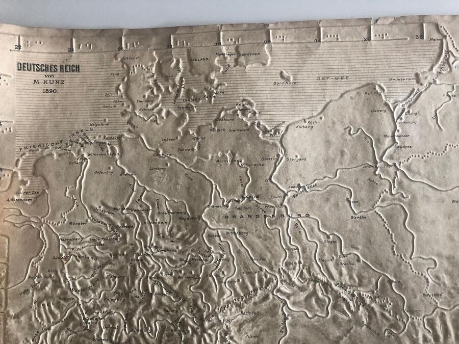
The typhlographic maps, which were made in Alsace, were among the first to be created for blind and visually impaired people, reports Gazeta Wyborcza. They use embossed cardboard or string to mark out geographical features, and include braille inscriptions.
The maps depict various places across Europe, including France, the Netherlands and Denmark. However, not all the information on the maps is factually correct.
“The interesting thing is that they were produced not only for France and Germany, but for all the countries in Europe,” Marek Jakubowski, the founder of the Typhlological Museum in Owińska, near Poznań, told Radio Kraków. “Through various routes, they found their way to Tyniecka Street [the Centre for the Blind and Visually Impaired].”
The maps had originally been stored at a school on Józefińska Street, but were subsequently moved to the centre, where they were kept in tubes, according to Gazeta Krakowska. Several years ago, however, they went missing, with staff believing they had been removed from the centre.
However, the maps were recently rediscovered by chance in the centre’s library by Jakubowski. It is now thought that they had originally been taken away from the centre, but were returned by the daughter of a former director.
Alongside the Alsace maps, Jakubowski also discovered others published in 1886 and 1890 by M. Kunz in Berlin and some produced in Danzig (now Gdańsk) between 1910 and 1915, by a director of a facility for the blind who had developed his own production technology.
Some of the maps still show traces of dirt from the hands of children who had used them. Following genetic research on similar maps kept at the museum in Owińska, it is estimated that one map would have been touched by around 700 people across history.
The Kraków centre is now planning to work with the city’s Jagiellonian Library to preserve the maps and present them as an exhibit, which will likely open after coronavirus restrictions are lifted.
“We will try to protect them so that they can be shown to future generations,” Marcin Dębski, the director of the centre, told Radio Eska. “These maps are not used anymore, so we want to present them to everyone interested in history.”
Poland's census discriminates against disabled and LGBT people as well as ethnic minorities, says human rights commissioner @Adbodnar.
It is inaccessible for the blind, stops some trans people choosing their gender identity, and forbids non-Polish letters https://t.co/tBD7WqTokA
— Notes from Poland 🇵🇱 (@notesfrompoland) April 20, 2021
Main image credit: press materials

Juliette Bretan is a freelance journalist covering Polish and Eastern European current affairs and culture. Her work has featured on the BBC World Service, and in CityMetric, The Independent, Ozy, New Eastern Europe and Culture.pl.